Guides
Feb 15, 2026
The Perfect 2-Day Snaefellsnes Peninsula Itinerary
This 2-day Snaefellsnes Peninsula itinerary highlights Iceland’s best scenery, from beaches and cliffs to mountains and volcanoes.
North Iceland is one of the country's most spectacular yet underrated regions. While most tourists stick to the Golden Circle and South Coast, those who venture north are rewarded with powerful waterfalls, incredible whale watching, otherworldly volcanic landscapes, and far fewer crowds.
This 7-day north Iceland itinerary will take you through the famous Diamond Circle route and beyond, exploring everything from Europe's most powerful waterfall to bubbling mud pools, dramatic canyons, and charming fishing villages.
.webp)
Your North Iceland adventure starts in Akureyri, the largest city outside of Reykjavik and a genuinely lovely base for the week. Most travellers fly into Reykjavik's Keflavik Airport and either take an internal flight to Akureyri (about 45 minutes) or drive north along Route 1, the famous Ring Road — a scenic drive of around 5 hours that passes some beautiful landscapes on the way.
If you arrive with energy to spare, Akureyri is well worth exploring. Head to the colourful Akureyri Botanical Gardens, which sit on a hillside above the town and are surprisingly lush for somewhere so far north.
Walk the main pedestrian street (Hafnarstræti) and stop for coffee or a bowl of soup at one of the cosy cafés — lamb soup is everywhere in Iceland and it is consistently good. The iconic Akureyrarkirkja church sits at the top of a wide staircase and gives you a panoramic view of the fjord below. It is worth the walk up.
In the evening, visit the Geosea Geothermal Sea Baths if they are open. This is not the Mývatn Nature Baths — it is a different facility right at the harbour edge in Húsavík (about an hour's drive).
Some travellers skip it here and do it on Day 5 instead, which works equally well. If you stay in Akureyri tonight, the town has a good range of restaurants with excellent fresh fish and lamb.
Tour Suggestion: If you are arriving a day early or have time on your first afternoon, a short Akureyri city walking tour is a great way to get your bearings and learn the local history.
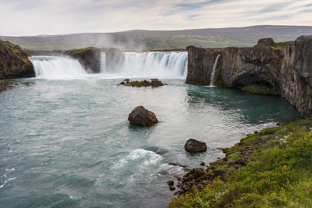
Drive about 35 minutes east from Akureyri and you will reach Goðafoss (pronounced roughly "Go-tha-foss"), one of the most beautiful waterfalls in all of Iceland. The name translates as "Waterfall of the Gods," and it comes from a remarkable historical moment.
In the year 1000 AD, when Iceland officially converted from Norse paganism to Christianity, a local chieftain called Þorgeir symbolically threw his pagan idols into the falls. The conversion was, by most accounts, entirely peaceful — and the waterfall has carried this weight of history ever since.
Standing at the edge of Goðafoss, you immediately see why it was chosen for such a significant gesture. The waterfall is 12 metres high and about 30 metres wide, with a curved horseshoe shape that sends water crashing down in multiple streams across a wide basalt ledge.
Walking paths on both sides of the river give you different angles — the west side has the most dramatic viewpoint for photos, while the east bank feels quieter and lets you get closer to the mist.
From Goðafoss, continue east to the Lake Mývatn area, where you will spend most of your afternoon. Mývatn (the name means "Midge Lake") is a shallow volcanic lake surrounded by some of the most extraordinary geology in Europe.
Start at the Skútustaðagígar pseudo craters — these are not real volcanic craters, but formed when lava flowed over a wetland and trapped steam, which exploded upward creating crater-like formations. Walking around and between them takes about 45 minutes and gives you a real sense of how strange this landscape is.
Next, drive to Dimmuborgir, which translates roughly as "Dark Castles." This is a field of contorted lava formations — pillars, arches, and tunnels — created thousands of years ago when lava drained beneath a hardened crust.
Several well-marked walking paths wind through it, ranging from 15 minutes to an hour. In Icelandic Christmas folklore, the 13 Yule Lads are said to live here, which adds a quirky charm to an already remarkable place.
Tour Suggestion: If you would rather not drive, a Lake Mývatn and Goðafoss guided day tour from Akureyri covers the waterfall, Dimmuborgir, Skútustaðagígar, and the geothermal areas in one well-paced day. This is a popular option for first-time visitors to the region who want expert commentary on the geology and folklore.
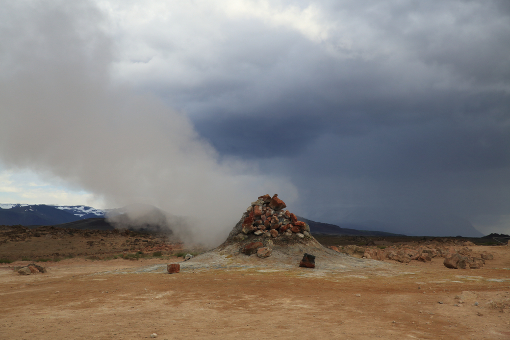
Today you stay in the Mývatn area and go deeper into the volcanic landscape. This is the day that tends to leave people genuinely speechless, because nothing really prepares you for what Hverir looks like in real life.
Hverir (also known as the Námafjall Geothermal Area) is a flat expanse of bubbling mud pots, steam vents, and sulphur-coloured earth that sits just off the Ring Road near the Námafjall mountain. The ground is orange, red, and yellow from the minerals, and everything is bubbling, hissing, and steaming at once.
The smell of sulphur is strong. Stay on the marked paths — the surface crust can be thin in places and the mud is boiling hot. It is completely safe if you are sensible, but this is genuinely wild geothermal activity, not a managed theme park. Walk slowly, look around often, and let the strangeness of the place sink in.
From Hverir, drive up to the Krafla volcanic area. Krafla is an active volcano that last erupted in 1984 — a series of eruptions called the "Krafla Fires" that lasted on and off for nine years. The Víti crater lake sits at the top: a vivid green-blue circle of water inside a volcanic crater, with walking paths around its rim. The Leirhnjúkur lava field nearby still steams from the ground, and you can walk across a landscape that is — in geological terms — almost brand new.
On the way back, stop at Grjótagjá, a small cave containing a geothermal spring with striking blue water. It was used as a bathing spot for decades and became famous globally after being used as a filming location for Game of Thrones.
Swimming is no longer permitted because the water temperature rose during the Krafla eruptions and has remained too hot for safe bathing, but visiting the cave and seeing the glowing water is absolutely worth the short detour.
End the afternoon with a long soak at the Mývatn Nature Baths — a geothermal lagoon of mineral-rich, milky-blue water that stays between 36°C and 40°C year-round. Think of this as the "Blue Lagoon of the North" — similar concept but far fewer people, a more natural setting, and significantly more affordable entry.
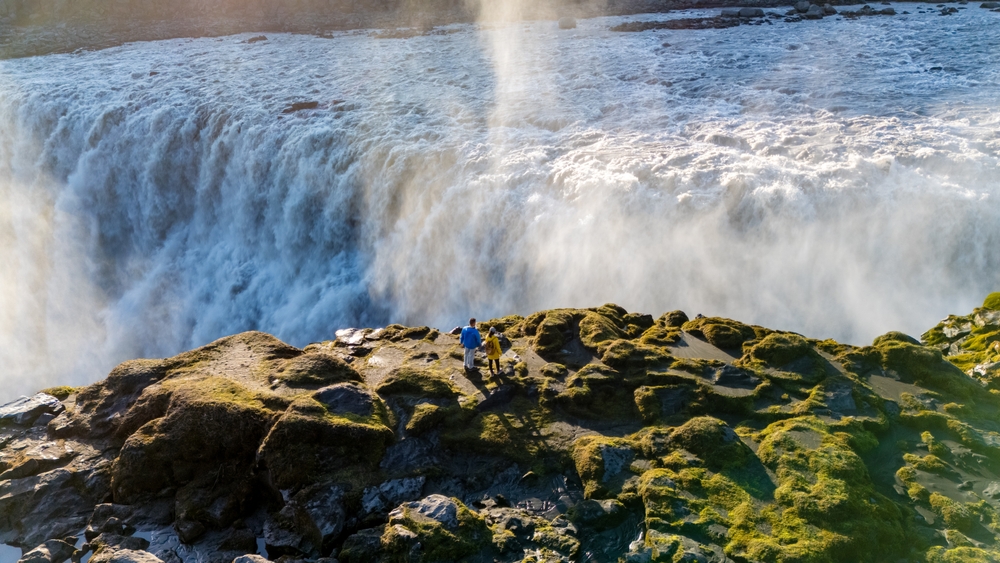
Today is dominated by one of the most dramatic natural sights in Iceland — and arguably in all of Europe. Dettifoss, located within Vatnajökull National Park, is often called the most powerful waterfall on the continent.
It is 44 metres high and 100 metres wide, and it carries roughly 193 cubic metres of water per second into a basalt canyon below. That number means very little until you are standing at the edge and feel the vibration through the ground beneath your feet.
The water that plunges over Dettifoss is glacial meltwater from the Vatnajökull glacier, and it carries so much sediment that it looks grey rather than clear. The spray from the falls creates a permanent mist cloud, and in good light you will often see rainbows forming in it.
Two access roads lead to Dettifoss — Route 864 (on the east side, unpaved but driveable in dry weather) and Route 862 (paved, approaching from the west). The west bank viewpoint is closest to the falls, while the east bank gives you a broader panorama of the canyon. If road conditions allow, visiting both sides is worthwhile. Allow yourself at least 90 minutes here. People rush it and regret it.
While you are in this part of the park, visit Selfoss, a smaller but prettier waterfall just a 15-minute walk upstream from Dettifoss, and Hafragilsfoss, downstream in the canyon. The canyon itself — Jökulsárgljúfur — is beautiful in every direction.
Dettifoss is about a 1-hour drive from the Mývatn area. Allow a full morning for the falls and canyon, and return via the Ring Road north toward Húsavík, where you will stay tonight. Húsavík is about 1 hour from Dettifoss.
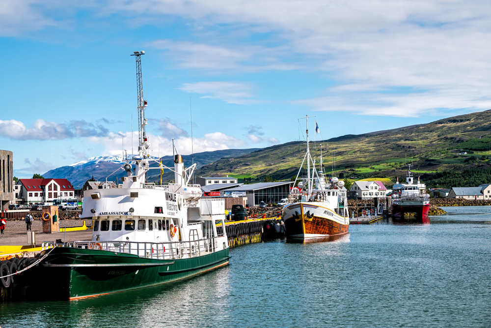
Húsavík is one of those small towns that has earned an enormous reputation. With fewer than 3,000 residents, it sits on a wide bay called Skjálfandi and has been welcoming whale watchers since the 1990s — making it Iceland's original and most celebrated whale watching destination, with a success rate that tour operators claim averages around 97% for sightings across the season.
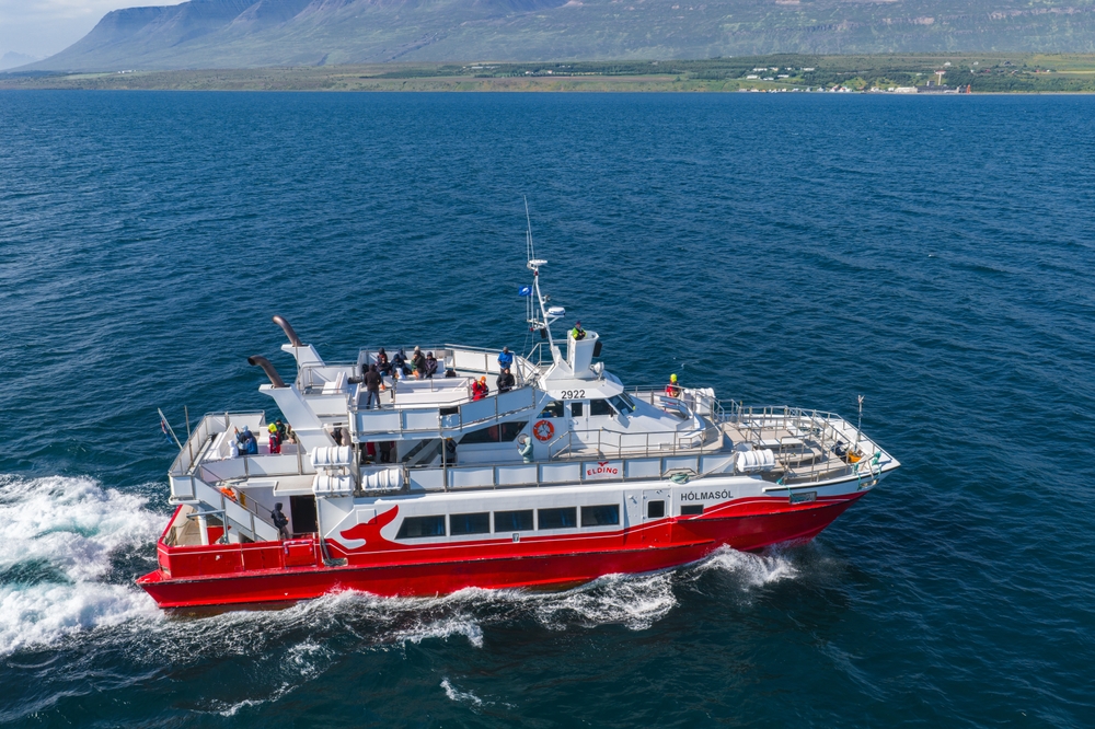
The bay is a feeding ground for humpback whales from April through October. You are very likely to see humpbacks, and minke whales are also common. White-beaked dolphins appear frequently. Blue whales — the largest animals on earth — are occasionally spotted, though sightings are never guaranteed. Most tours run for 2 to 3 hours from the harbour, and operators typically provide warm waterproof overalls because the bay gets cold even in summer.
Before or after your tour, visit the Húsavík Whale Museum right by the harbour. It houses impressive whale skeletons, well-designed exhibits about whale biology and conservation, and hands-on displays.
Húsavík is also the town featured in the Netflix movie Eurovision Song Contest: The Story of Fire Saga, and you will see references to it all over town. The original song "Húsavík (My Home Town)" from the film was even nominated for an Academy Award.
It adds a fun, quirky layer to an already charming place. After your whale watching, have lunch at one of the harbour-side restaurants — the lobster soup (actually langoustine) is exceptional, and you will find it on most menus in town.
In the late afternoon, if you have not done the Geosea Geothermal Sea Baths yet, this is the ideal moment. Perched on a cliff overlooking the bay, it is one of the most dramatically situated geothermal pools in Iceland, and soaking here as the light changes over the water is a wonderful way to end an already excellent day.
Today you complete the Diamond Circle by visiting Ásbyrgi Canyon, then take one of the most scenic drives in northern Iceland as you head west toward the fishing town of Siglufjörður.
Ásbyrgi is a horseshoe-shaped canyon, 3.5 kilometres long and 1 kilometre wide, with vertical cliff walls rising to about 100 metres on either side. Norse mythology says Odin's eight-legged horse Sleipnir touched down here, leaving a hoof print so large it became a canyon.
The floor of the canyon is a peaceful woodland of birch trees and wildflowers, with well-marked hiking trails ranging from short walks to longer rim hikes. A small pond at the heart of the canyon, ringed by rock faces, is extraordinarily still and beautiful.
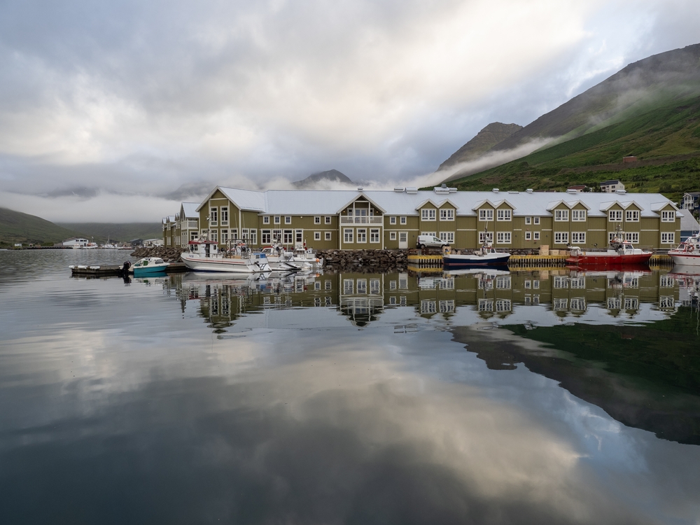
From Ásbyrgi, drive west and north toward Siglufjörður, a remote fishing town tucked into a narrow fjord at the tip of the Tröllaskagi Peninsula. The drive is roughly 2.5 hours, passing through the Héðinsfjörður tunnel system and along fjord roads with sweeping mountain views.
Siglufjörður itself is well worth the detour — the Herring Era Museum is one of the best museums in Iceland, telling the story of the town's dramatic past as the herring capital of the North Atlantic in the mid-20th century.
Your final full day can take one of two directions depending on your flights and energy levels. If you are flying home from Akureyri, a relaxed morning in the city with a final bowl of lamb soup and perhaps a visit to the hot pot at the local swimming pool (extremely local, very cheap, and wonderfully pleasant) is a perfectly satisfying ending. If you have flexibility, there are two stops that reward a longer final day.
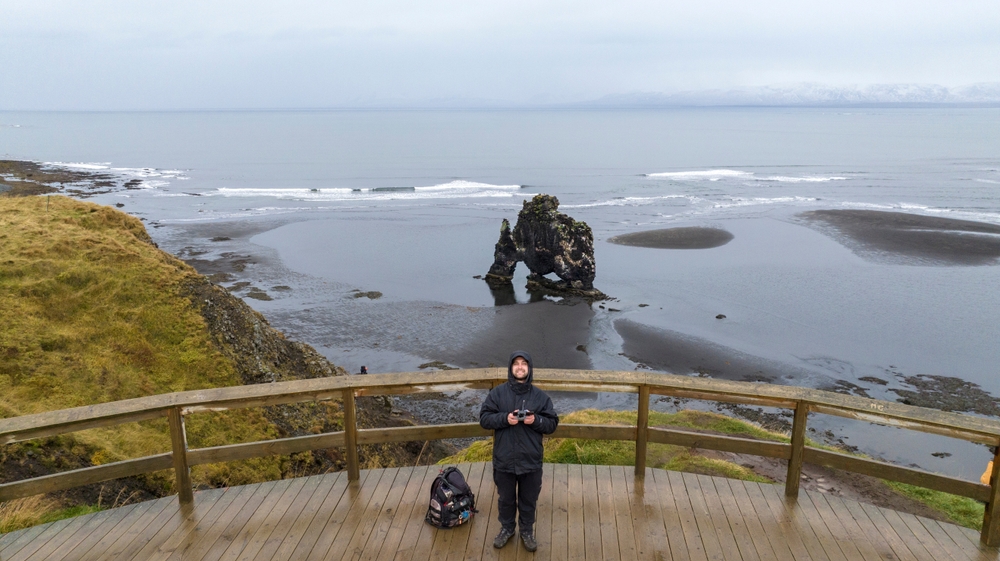
Hvítserkur is a 15-metre-tall basalt sea stack on the west coast of the Vatnsnes Peninsula, south of Akureyri. It rises from the sea at low tide and is shaped, with only modest imagination, like a rhinoceros drinking from the water.
It is an arresting sight, especially in early morning or evening light when the colours are warm. Getting there requires a short walk down a cliffside path, and the viewpoint above is also excellent. At low tide you can get very close to the base of the rock across the beach.
The Skagafjörður Valley, also to the south and west of Akureyri, is Iceland's horse country — more Icelandic horses per capita here than anywhere else in the country, grazing across a wide river valley with snow-capped mountains on both sides.
The medieval church at Hólar was once the most important religious and cultural centre in northern Iceland. The historic buildings and peaceful setting make for a quiet, reflective end to the week.
Drive back to Akureyri for your flight, or continue south on the Ring Road toward Reykjavik — the drive takes about 5 hours and the Kjölur highland route (summer only) offers a spectacular cut through the interior.
No, you do not need a 4WD to drive in North Iceland if you stay on main roads in good weather. Most major attractions are accessible via paved roads, though a 4WD is recommended in winter or if you plan to drive gravel roads or mountain routes.
The best time to go whale watching in Húsavík is from late spring through summer. Peak sightings typically occur between late spring and early fall, when humpback whales and other species are most active in the bay.
The Diamond Circle is a scenic driving route that connects North Iceland’s top natural attractions. This loop typically includes waterfalls, volcanic lakes, geothermal areas, and coastal towns, making it one of the region’s most popular road trips.
Yes, North Iceland is a great destination for families traveling with children. Waterfalls, short walks, whale-watching tours, and geothermal baths make the region engaging while still manageable for younger travelers.
Unlock Iceland's Best Kept Secrets: Sign Up Now for Exclusive Travel Stories and Special Offers!